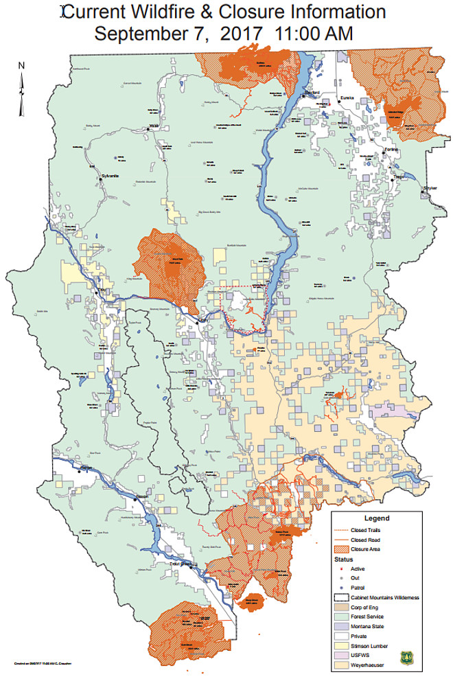
The Gibralter Ridge Fire is still at 7,291 acres and 27 percent contained. Firefighters will continue to mop-up, patrol and monitor the fire’s gradual growth toward William’s Creek. Crews have placed sprinklers and continue to patrol in pre-evacuation areas. The firelines continue to hold and fire growth is minimal. Pre-evacuation warnings and closure orders are still in place in the fire areas.
The Caribou Fire increased a couple hundred acres to 20,631 acres with 10 percent containment. Additional resources have been assigned to the fire, but aircraft will not be able to resume until the smoke clears and visibility improves. Fire crews and heavy equipment were used to improve fire line to the west and north, while joining lines to the south. Structure protection will continue to be the priority and area closure orders remain in place for the Caribou Fire. A full evacuation order remains in effect for the West Kootenai area. Fire managers will continue coordinating with Canadian fire managers on fire suppression activities.
The West Fork Fire is estimated at 7,337 acres at zero percent containment. This fire is exhibiting moderate fire behavior and backing in multiple directions. The planned burnout yesterday was successfully completed to Lindy Peak. This operation was done in the Bobtail Ridge and Bobtail Ridge Road area. Crews today will monitor/hold what was burned east of the Quartz Road. A crew patrolled/monitored the burnout area throughout the night. Fire crews will continue to construct containment lines along the southern boundary of the fire. Structure protection and evaluating values at risk remain the priority. Pre-evacuation and evacuation orders are in effect for areas near the West Fork Fire. New evacuation orders have issued, please check the Lincoln County Sheriff’s Facebook page.
The Moose Peak Fire is estimated at 5,717 acres at zero percent containment. This fire is exhibiting moderate fire behavior, torching, spotting, and backing in multiple directions. Fire crews will continue construction of containment lines on the eastern side of the fire. Structure protection assessment and evaluating homes are on-going in the Fisher Creek and McGinnis Meadows areas.
Closure orders remain in place for the Moose Peak Fire.
The Highway 200 Complex fires total 18,722 acres and is at different stages of containment. Minimum fire growth has occurred over the last few days and suppression tactics have been largely successful. Weather and limited firefighting resources continue to challenge fire operations. Structure protection assessment and strengthening existing containment lines will continue to be the priority. Once visibility improves, aircraft will again be able to fly and assist ground crews.
Firefighters will continue mop-up and patrol of the Readers Fires and have shifted some of those resources to the Cub Creek Fire. This fire is expected to continue growing south toward the Clear Creek drainage.
Firefighters and heavy equipment will be used to construct and improve existing containment lines. A hot shot crew is working in the Deep Creek area to prevent the fire from crossing the creek. Area closures are currently in place around immediate fire areas and areas integral to safe fire operations.
Due to the large number of area fires, air quality and visibility will continue to be very poor. People with smoke sensitivities, should limit their exposure and exertion while outdoors. For more information please visit www.todaysair.mt.gov.
Stage II Fire Restrictions are in effect for Lincoln County and Kootenai National Forest due to extreme fire danger and the Kootenai Forest is looking at larger area closures around the fire areas.
As hunting season progresses, please respect area fire closures. Protection of human life, both that of firefighters and the public is the overriding priority.
Current fire conditions can be found at www.firerestrictions.us. Go to the Kootenai webpage at https://www.fs.usda.gov/kootenai for the latest on Closure Orders, Kootenai Forest fire maps, and other fire information. The information on the Gibralter Ridge, Caribou, West Fork, Moose Peak, and Highway 200 Complex can also be found at https://www.inciweb.gov.
For up to date information about area fires, please visit any of the websites listed above.