|
April Fools' weather and power outage hits
Boundary County |
|
April 2, 2018 |
 Mother
Nature pulled off the biggest April Fools' prank
of them all, when on April Fools' Day yesterday
she slammed all of us who were gearing up for
Spring with cold temperatures, a lot of snow,
and a power outage to top it off. Mother
Nature pulled off the biggest April Fools' prank
of them all, when on April Fools' Day yesterday
she slammed all of us who were gearing up for
Spring with cold temperatures, a lot of snow,
and a power outage to top it off.
And by the way, Happy Spring Break! to Boundary
County students, whose first day of Spring Break
is today.
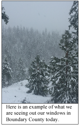
The accompanying photograph shows the remarkable
Spring Break weather Boundary County students
are enjoying on this the first day of Spring
Break 2018.
We are part
of a bigger picture
Boundary County is part of the western flank of
a large winter storm with high predicted
snowfalls, extending from our Northern Rockies
area, going across the northern United States
upper plains area, and into the Great Lakes
region.
Local weather
conditions and forecasts
Our local area continues today in a Winter
Weather Advisory issued by the National Weather
Service. According to the National Weather
Service, the advisory includes: "Northern
Panhandle-Central Panhandle Mountains, including
the following locations Sandpoint, Bonners
Ferry, Priest River, Eastport, Schweitzer
Mountain Road, Kellogg, Pinehurst, Osburn,
Wallace, Mullan, Fourth of July Pass, Dobson
Pass, and Lookout Pass."
Locally, the National Weather Service is warning
that "a series of wet storm systems with rising
snow levels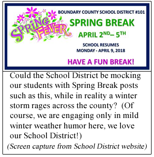 beginning Wednesday and lasting into the
weekend, along with melting snow, will lead to
small stream flooding concerns this weekend over
the [North Idaho] area. The risk of mudslides
and debris flows on steep terrain will also
increase during this wet period."
beginning Wednesday and lasting into the
weekend, along with melting snow, will lead to
small stream flooding concerns this weekend over
the [North Idaho] area. The risk of mudslides
and debris flows on steep terrain will also
increase during this wet period."
Currently, the National Weather Service is
predicting chance of scattered snow showers at
50%, later decreasing to 20% through the day
today. Tomorrow's prediction is 20% chance of
rain / snow with high temperatures around 44
degrees. Wednesday's forecast is 50% chance of
rain / snow, with rain showers predicted on into
Thursday.
Weather experts say this winter storm comes to
us thanks to a dip in the jet stream which
extends southward over the Rockies into the
central Plains, the Midwest and Northeastern
United States.
Major power
outage through the night
And on top of the snowy storm, thousands in our
area were hit by power outages, hitting late
last night and extending into the early hours of
this morning. At one point Northern Lights, Inc.
was saying over 3,400 customers in their service
area were without power. The outages included
areas around Bonners Ferry extending northward
into Porthill and Eastport areas, the Moyie
River / Meadow Creek Road, east along U.S.
Highway 2 through Moyie Springs, and western
Montana around the Troy and Yaak areas.
Northern Lights posted information during the
night saying that Bonneville Power
Administration was "having an unexpected outage
in Troy, Yaak, Bonners, and Mt. Hall areas."
Bonneville Power is the federal agency that
markets the power produced from all
federally-owned hydroelectric projects in the
Pacific Northwest. Apparently our local outages
have been related to Bonneville Power
transmission.
Today Northern Lights is saying "Wet heavy snow
is causing widespread outages in the northern
part of our territory. Crews have been in the
field all night making repairs and will continue
to do so until resolved. Please report your
outage to 1-866-665-4837."
At the time of this writing, Northern Lights is
indicating that over 500 customers are still
without power. These current outages seem to be
concentrated at this time in the Eastport, Round
Prairie, Moyie River areas, also Moyie Springs
and Yaak, Montana. |
|
Questions or comments about this
article?
Click here to e-mail! |
|
|
|
|