|
Frozen rain, sleet expected |
|
January 15, 2017 |
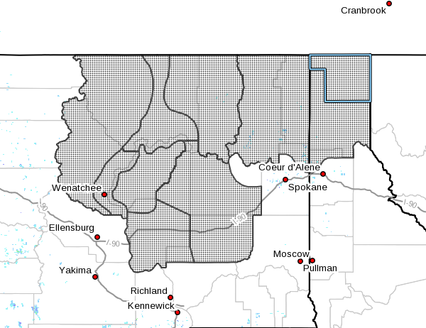 |
The National Weather Service has issued a winter
storm watch for North Idaho and northeast
Washington for freezing rain from this evening
through Wednesday morning. Update:
The National Weather Service on Monday adjusted
the timing of this event to Tuesday morning and
extended its duration to Wednesday night.
"A deep fetch of subtropical moisture noses into
the region starting Monday night and lingers
through midweek," they wrote. "This warm, moist
conveyor belt will overrun a very cold air mass
currently in place, bringing the potential for
several hours of freezing rain, sleet and high
mountain snow. Significant ice accumulations
will be possible within the Cascade valleys,
western Columbia Basin and northern mountain
valleys."
Ice accumulations are expected to be from 0.15
to 0.30 inches, with some localized areas
receiving up to half an inch of ice from both
freezing rain and sleet. Periods of light to
moderate rain and sleet mixed with snow is
expected to begin falling tonight, and become
steady with moderate intensity through Tuesday
afternoon, when precipitation is expected to
turn to mostly rain. The chance of rain
continues through Wednesday, but the
possibility of ice will be considerably
diminished as temperatures warm into the mid 30s
to low 40s..
At the expected accumulation of ice, roads will
be treacherous and, helped by south winds of 5
to 15 miles per hour with gusts to 25 miles per
hour, trees and power lines could be damaged,
and power outages are possible, if not likely. |
|
Questions or comments about this
article?
Click here to e-mail! |
|
|
|
|