|
|
|
Record Alaskan storm leading to freezing
temperatures here |
|
November 8, 2014 |
(See photo at end
of article)
Make the most of Boundary County's brilliant
sunshine and relatively nice autumn temperatures
while we have them this weekend. Drastic changes
are on the way.
Today, while here we have been enjoying
temperatures near 50 degrees with abundant
sunshine, the Aleutian Islands in Alaska have
been pounded with storm conditions including
wind gusting to near 100 mph and ocean waves the
size of a five-story building.
This Aleutian Island weather system, one of the
worst storms ever recorded there, will
eventually exert its impact on the lower 48
states. As it pushes wintry conditions
southward, forecasters are saying that about 2/3
of the lower 48 states will be affected with
temperatures dropping 10-20 degrees below
average for this time of year.
Here locally, temperatures will begin to drop by
early Monday. A high temperature of 36 degrees
is anticipated for Monday (with a low
temperature 16 degrees). Tuesday and Wednesday
highs are expected to be in the 20s, and
hovering right around freezing for the remainder
of the week.
In other areas of the nation, including the
upper plains, and the midwest, this same weather
system will deliver snow along with those cold
temperatures, in some places up to a foot.
Single digit temperatures are expected for parts
of Montana. This cold weather system will
eventually work its way to the East Coast.
All of this got started back on October 28. On
that day, while we were carving pumpkins, buying
Halloween candy, and getting kids' costumes
ready here in Boundary County, this storm system
was being born 6,000 miles away in the ocean
near Guam. By Halloween Day, while we were all
trick-or-treating during a fairly pleasant
Halloween evening, that storm was upgraded to a
tropical storm.
By the next day, while our local kids were
munching on their Halloween haul, the storm had
progressed to typhoon status, and was making its
way toward the Aleutians. The next day, it was
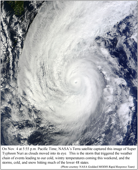
being classified as a super typhoon, named Super
Typhoon Nuri, with some sustained wind speeds up
to 180 miles per hour.
The low pressure system associated with Super
Typhoon Nuri were lower than even Superstorm
Sandy. With those conditions and low pressure,
Nuri became the most intense extratropical
cyclone ever known over the North Pacific since
such record keeping began.
Nuri weakened on November 4, but its remnants
slammed the Bering Sea and Alaska's Aleutian
Islands, and was described as the most powerful
storm to hit the Bering Sea in known history.
And that's the storm whose effects will bring
our subfreezing temperatures to Boundary County
and the rest of the lower 48 this week, all
having started 6,000 miles away eleven days ago.
This is the week to start unpacking the winter
gear!
|
|
|
|
Questions or comments about this
article?
Click here to e-mail! |
|
|
|
|