|
|
|
Boundary County mountain snowpack and
precipitation so far this year |
|
December 8, 2015 |
Last winter, instead of enjoying winter snows
and a growing snowpack in the mountains,
Boundary County and the region had warmer
temperatures, frequent rains, and a lack of
snow. We had plenty of precipitation in the form
of rainfall, but not much accumulation of a
mountain snowpack at all. This was followed by a
dry summer marked by significant forest fires
across the Idaho Panhandle. All this was the
basis for concerns about our water supply for
the 2015 water year for the region.
The water year is measured each year beginning
October 1, running through September 30.
Currently, we are about two months into the new
2016 water year. Experts have looked at
scientific data and projections to try to make
educated predictions on the snowpack and
precipitation for the 2016 water year. A big
factor that plays a part in the analysis is El
Niño, which this year is predicted to be one of
the stronger El Niños on record.
El Niño affects different parts of the United
States in different ways. In the Pacific
Northwest, it seems to bring warmer than average
temperatures, and below average precipitation.
This has led to predictions that we might
possibly have a warmer and drier winter again
this year.
Whether those predictions will be borne out or
not in the long run, the snowpack so far in
Boundary County is OK for now.
Instruments located at Boundary County's Hidden
Lake and at Myrtle Creek measure precipitation
and the snowpack in those areas. At this point,
early in the water year, data from those
instruments are showing good numbers for both
our current snowpack and the accumulated
precipitation in Boundary County--so far.
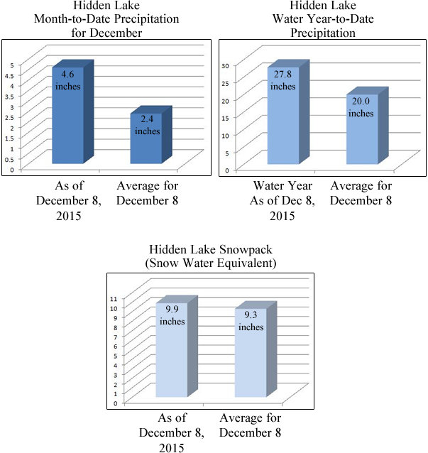
At Hidden Lake, located in the west side
mountains of the north west part of Boundary
County, precipitation for our current month of
December, as of readings taken just this
morning, is 4.6 inches, which is 192% of the
average for the first eight days of December.
For the 2016 water year since October 1, Hidden
Lake precipitation totals 27.8 inches, which is
139% of the year-to-date average number for
December 8.
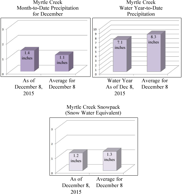
At the other data collection site at Myrtle
Creek, located just west of the Kootenai
National Wildlife Refuge, December precipitation
stands at 1.4 inches as of today, which is 127%
of the average month-to-date amount for December
8.
Water year-to-date precipitation at Myrtle Creek
is 7.1 inches, which is 86% of our usual
year-to-date average.
This precipitation has led to good snowpacks so
far in the water year. At Hidden Lake, snowpack
as of today is 9.9 inches (measured as Snow
Water Equivalent), which is 106% of the average
for December 8. Myrtle Creek snowpack today is
1.2 inches, which is 92% of the usual December 8
average.
Interestingly, with recent rainfalls, these
numbers have climbed steadily. For example, the
Hidden Lake instrument site showed precipitation
climbed 1.1 inch from yesterday, December 7,
through today, December 8, with Myrtle Creek
adding 0.2 inch precipitation over the past 24
hours.
For those of us who like to see our numbers
presented in convenient easy-to-follow graphical
format, our NewsBF graphics staff has prepared
the following pictorial representations of the
above information:
. .
. . .
. .
. .
. . .
. .
. .
. . .
. .
.
Temperatures are predicted to remain somewhat
high for the next few days, into the mid 40s.
These temperatures could potentially adversely
affect our mountain snowpack.
Click here
for weather alert story: possible damaging winds
and heavy rainfall today. |
|
|
|
Questions or comments about this
article?
Click here to e-mail! |
|
|
|
|