|
|
|
Precipitation and snowpack continue to look good
for now, but experts caution they may not hold
up |
|
December 23, 2015 |
 Take
a look at your window right now. Take
a look at your window right now.
Chances are, you'll see it is snowing right now
in Boundary County.
As of today, December 23, Boundary County
continues to do well in its precipitation
profile for the water year, and in our area's
accumulated mountain snowpack.
However, experts continue to be cautious and to
express concern about what might happen with
both our precipitation and our snowpack as El
Niño exerts its effects in the coming winter
months.
The water year is measured each year beginning
October 1, running through September 30.
Instruments located at Boundary County's Hidden
Lake and at Myrtle Creek measure precipitation
and the snowpack in those areas. As of today,
data from those instruments are showing good
numbers for both our current snowpack and the
accumulated precipitation in Boundary County for
this point in the water year.
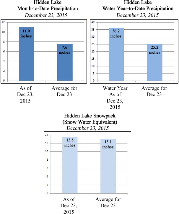
At Hidden Lake, located in the west side
mountains of the north west part of Boundary
County, precipitation for our current month of
December, as of readings taken just this
morning, is 11.0 inches, which is 145% of the
average for this point in December. (See our
handy graphs below). For the full 2016 water
year since October 1, Hidden Lake precipitation
totals 36.2 inches, which is 144% of the
year-to-date average number for December 23.
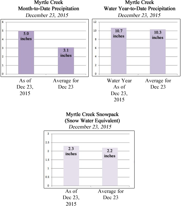
At the other data collection site at Myrtle
Creek, located just west of the Kootenai
National Wildlife Refuge, December precipitation
stands at 5.0 inches as of today, which is 161%
of the average month-to-date amount for December
23.
Water year-to-date precipitation at Myrtle Creek
is 10.7 inches, which is 104% of our usual
year-to-date average for this point in December.
Our precipitation since October 1 continues to
provide good snowpacks so far in the water year.
At Hidden Lake, snowpack as of today is 13.5
inches (measured as Snow Water Equivalent),
which is 103% of the average for December 23.
Myrtle Creek snowpack today is 2.3 inches of
Snow Water Equivalent, which is 105% of the
usual December 23 average.
Take a look at these dazzling graphs, created by
our official NewsBF Graphics Department:
(Note: the story continues
below these graphs)
. . . . .
. . . .
. . . .
. . . .
. . . .
. . . .
. . . .
. . . .
. . . .
. .
With all this great winter precipitation and
accumulating snowpack, it's nice to imagine a
nice spring runoff come April, along with all
the water we'll need for the summer months.
But some of the country's weather and climate
experts are expressing concern that weather
patterns coming in the next couple of months may
disrupt that rosy spring picture. A big factor
in these predictions has to do with the El Niño
weather phenomenon. An El Niño occurs when sea
surface temperatures in the equatorial Pacific
Ocean warm up. These increased ocean surface
temperatures can then influence air and moisture
movement in weather patterns around the globe.
"People the world over are feeling, or soon will
feel, the effects of the strongest El Niño event
since 1997-98, currently unfolding in the
eastern equatorial Pacific Ocean," says the
NASA/Goddard Space Flight Center in a press
release issued last week.
The National Weather Service Climate Prediction
Center goes back even farther in describing this
year's El Niño, noting they expect it to rank
among the strongest three dating back 65 years
to 1950. In their November 2015 Forecast Forum
last month, the Climate Prediction Center
further stated, "Most models indicate that a
strong El Niño will continue through the
Northern Hemisphere winter 2015-16."
So what does all that have to do with Boundary
County?
The Climate Prediction Center recently released
its Three Month Official Forecast for
January-February-March of 2016. That forecast
shows above average predicted temperatures for
the Pacific Northwest including the Idaho
Panhandle, and below average probability of
precipitation for the area.
So these experts are saying come January, and
likely from that point through the remainder of
this winter, we may be having less
precipitation, and higher than usual
temperatures. Should those forecasts hold up, we
may once again see early warming and early
runoff of our mountain snowpacks, and lower
precipitation for a big part of our winter
months.
No one can say for sure, but those are the
forecasts from the experts at this point in the
season, based on data available at this time.
Here's hoping us good water luck for the year!
|
|
|
|
Questions or comments about this
article?
Click here to e-mail! |
|
|
|
|